Distance: 28 km
Elevation: 230 m up to pass and then 625 down to Mt. Shark parking lot
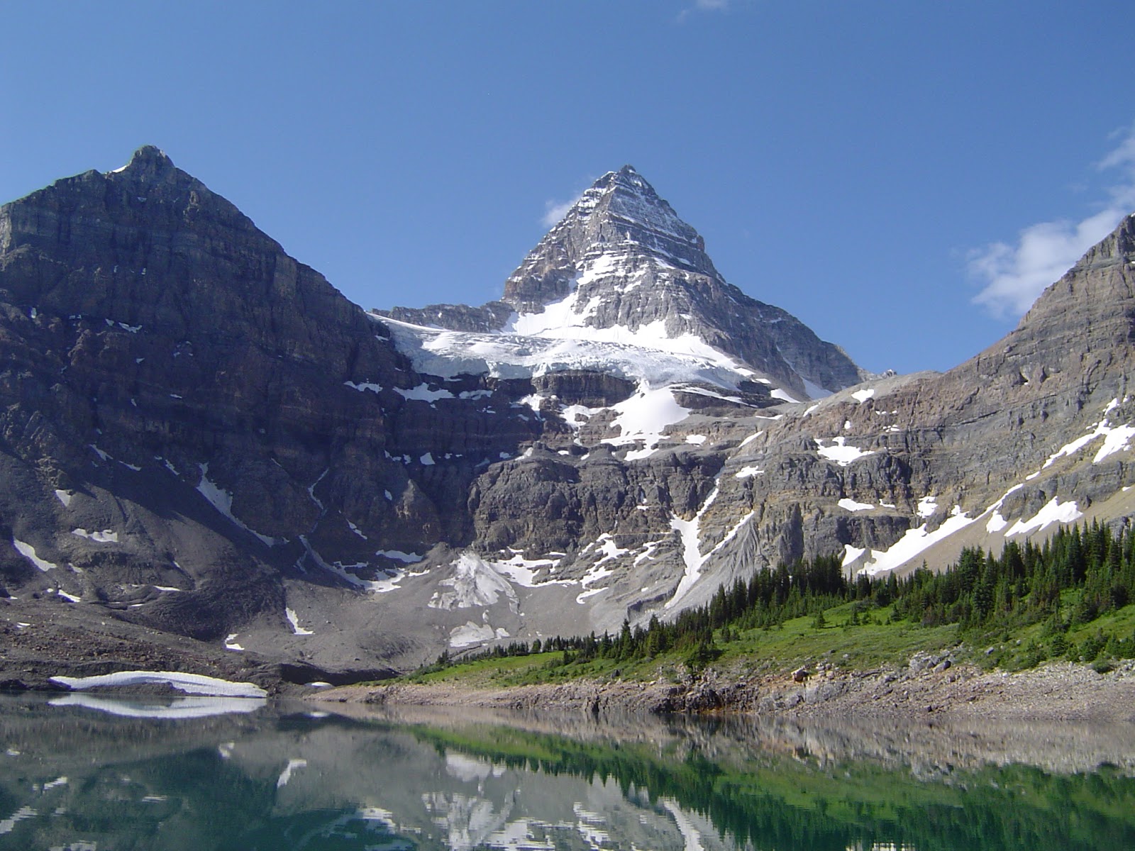
Thursday, we rested and soaked in the sun beside Lake Magog and Mt. Assiniboine. Then, Friday, we got up around 5:30, in the dark, ate breakfast and packed up wet tents and our gear. We dropped the backpacks off at the lodge for the helicopter to fly to Canmore and set off for Mt. Shark shortly after 8:00am.
We decided to go out via Wonder Pass to discover a new route and to go easier on our blisters. It was a little sad to say goodbye to Mt Assiniboine but we were looking forward to a warm, soapy shower at home.
The meadows were full of flowers but these western anemones and paintbrushes dominated.
The blue sky again was a good promise of a great hiking day.
Herm decided to doctor up his blisters one more time before descending the pass. Mole skin and bandaids were very effective and we coped very well.
Herm was using his old, light camera for this trip and it gave trouble all along. The flowers on this Friday hike was the last photo he could coax out so Khosrow sent us his shots. We started down over the pass, down, down, down.
Soon there was a beautiful view of Gloria Lake (and us).
A lot of the hike went along and above a second lake - Marvel.
Finally we came to McBride`s Camp where we ate lunch at the stream. From here (almost halfway) the trail broadened into a narrow road with some streams and bridges and one long steep hill. We looked forward to dipping into Watridge Lake but when we got there and saw it meant going down first, we decided to skip it and just continue to Mt. Shark. Our feet were sore, our water gone and the end looked very good.
After about 9 hours we arrived at the parking lot, got a ride to Engadine Lodge and waited for Margaret to come from Sunshine to pick us up. It was a very good hiking adventure.
Monday, 8 August 2016
56. Wonder Pass Viewpoint
Distance: 10 km
Elevation:
Wednesday, July 27, was another sunny day for another local hike. We set off across boardwalks, past the Naiset huts(huts providing cover and cooking facilities) toward Wonder Pass to see some more lakes.
Our first snack stop was at a lovely falls cutting through the meadow and woods.
Our trail continued up gently to Wonder Pass.
Herm and I went over the pass to the viewpoint while the others climbed to Wonder Peak on the left and found an alternate route back down. We were favouring our blisters.
Looking over the pass, we could see the beginning of our trail back to Mt. Shark on Friday.
It was a special treat to see this spruce grouse with about 6 young chicks walking ahead of us on the trail to the viewpoint.
Deep blue Gloria Lake was visible from the viewpoint. Helicopters flew tourists regularly over Gloria and Marvel Lakes and the glaciers on the mountains.
Of course we ate lunch at the viewpoint and relaxed at length while we forgot about the others hiking around the peak.
Then, back to the lodge for a glass of wine or beer and cake and chatting with fellow hikers who we were beginning to recognize.
Elevation:
Wednesday, July 27, was another sunny day for another local hike. We set off across boardwalks, past the Naiset huts(huts providing cover and cooking facilities) toward Wonder Pass to see some more lakes.
Our first snack stop was at a lovely falls cutting through the meadow and woods.
Our trail continued up gently to Wonder Pass.
Herm and I went over the pass to the viewpoint while the others climbed to Wonder Peak on the left and found an alternate route back down. We were favouring our blisters.
Looking over the pass, we could see the beginning of our trail back to Mt. Shark on Friday.
It was a special treat to see this spruce grouse with about 6 young chicks walking ahead of us on the trail to the viewpoint.
Deep blue Gloria Lake was visible from the viewpoint. Helicopters flew tourists regularly over Gloria and Marvel Lakes and the glaciers on the mountains.
Of course we ate lunch at the viewpoint and relaxed at length while we forgot about the others hiking around the peak.
Then, back to the lodge for a glass of wine or beer and cake and chatting with fellow hikers who we were beginning to recognize.
55. Assiniboine Lakes-Nublet
Distance: 11km circuit
Elevation: 540 metres to Nublet
Tuesday, July 26, dawned sunny and warm. We were all up for an easier, shorter walk in the environs of the camp. We set out after 10 am.
The first little lake was Sunburst.
We walked beside it to the next one.
Cerulean Lake, circling a distinctive mountain with scree piles.
The next one was Elizabeth Lake where we soaked our feet and ate lunch. A few girls from the lodge made a practice of dunking in all 4 lakes (Magog also) on nice days.
From the pass the trail back down to the lodge looked more inviting than the trail up to the Nublet, so I went down while most of the others went up for a better look and pictures.
It was getting close to 5:00pm and the clouds were coming in as usual so everyone hurried down to beat the rain and enjoy a drink and cake at the lodge.
Shelter and rest for weary hikers at the lodge with a view of Magog, the 4th lake.
Elevation: 540 metres to Nublet
Tuesday, July 26, dawned sunny and warm. We were all up for an easier, shorter walk in the environs of the camp. We set out after 10 am.
The first little lake was Sunburst.
We walked beside it to the next one.
Cerulean Lake, circling a distinctive mountain with scree piles.
The next one was Elizabeth Lake where we soaked our feet and ate lunch. A few girls from the lodge made a practice of dunking in all 4 lakes (Magog also) on nice days.
From the pass the trail back down to the lodge looked more inviting than the trail up to the Nublet, so I went down while most of the others went up for a better look and pictures.
It was getting close to 5:00pm and the clouds were coming in as usual so everyone hurried down to beat the rain and enjoy a drink and cake at the lodge.
Shelter and rest for weary hikers at the lodge with a view of Magog, the 4th lake.
Saturday, 6 August 2016
54. Sunshine Meadows to Assiniboine
Distance: 29 km
Elevation: climbed and descended 1000 m according to GPS
July 25, we started our hike in to Assiniboine Provincial Park BC from the Sunshine Meadows lodge where the shuttle from the parking lot dropped us off. This was to be a 5-day hiking camping adventure organized by Margaret. We carried only our day packs and flew the camping gear and extra food in by helicopter. We divided into 2 groups right away so one group could wait for Margaret who had missed the Sunshine turnoff.
The trail was smooth, through wide, green meadows and offered periodic views of Mt. Assiniboine, the king of the region. It was good to leave the lodge where the mosquitoes were abundant and vicious. The green grass and bright blue sky were encouraging markers for success on this long hike.
We saw a rise before us, was that the pass already? No, it was a climb over a ridge to look over Howard Lake.
And then on the other side a steep descent down to the lake and Assiniboine in the distance.
The meadows, mountains and good trail made the walking pleasant.
At about 10 km, we came to Citadel Pass and noted the citadel-like rock beside us.
Mt Assiniboine was getting bigger, we were making progress. It was now in the clouds, would our sunshine hold?
Many hikers backpack in and stop at Porcupine Camp. Our trail passed above the drop down to the camp and water.
The next remarkable feature was the Valley of the Rocks which extended a fair distance and was aptly named.
Around here at around 5pm it started to rain. Not pour but enough to wear rain gear, get wet feet and blisters. It also produced puddles in our way so that we were forced to contribute to the trail braiding.
By the time we got to Og Lake, another campground, the sun was shining again although not all over.
Another 7 km and we were at the lodge to pick up our backpacks and do the final km to the campground where Herm had hopefully already put up our tent.
Lake Magog and Mt Assiniboine from the lodge were beautiful but even more so as we carried our packs around the lake and walked in closer. Yes, my tent was up!
Elevation: climbed and descended 1000 m according to GPS
July 25, we started our hike in to Assiniboine Provincial Park BC from the Sunshine Meadows lodge where the shuttle from the parking lot dropped us off. This was to be a 5-day hiking camping adventure organized by Margaret. We carried only our day packs and flew the camping gear and extra food in by helicopter. We divided into 2 groups right away so one group could wait for Margaret who had missed the Sunshine turnoff.
The trail was smooth, through wide, green meadows and offered periodic views of Mt. Assiniboine, the king of the region. It was good to leave the lodge where the mosquitoes were abundant and vicious. The green grass and bright blue sky were encouraging markers for success on this long hike.
We saw a rise before us, was that the pass already? No, it was a climb over a ridge to look over Howard Lake.
And then on the other side a steep descent down to the lake and Assiniboine in the distance.
The meadows, mountains and good trail made the walking pleasant.
At about 10 km, we came to Citadel Pass and noted the citadel-like rock beside us.
Mt Assiniboine was getting bigger, we were making progress. It was now in the clouds, would our sunshine hold?
Many hikers backpack in and stop at Porcupine Camp. Our trail passed above the drop down to the camp and water.
The next remarkable feature was the Valley of the Rocks which extended a fair distance and was aptly named.
Around here at around 5pm it started to rain. Not pour but enough to wear rain gear, get wet feet and blisters. It also produced puddles in our way so that we were forced to contribute to the trail braiding.
By the time we got to Og Lake, another campground, the sun was shining again although not all over.
Another 7 km and we were at the lodge to pick up our backpacks and do the final km to the campground where Herm had hopefully already put up our tent.
Lake Magog and Mt Assiniboine from the lodge were beautiful but even more so as we carried our packs around the lake and walked in closer. Yes, my tent was up!
Friday, 15 July 2016
53. Rae Lake
Distance: 17.2 km return
Elevation gain: 366m
We had tried to hike to Rae Lake last fall but the path was under snow so we gave up and continued on to Tombstone Lakes which was easier to find. However, the trail looked so beautiful that I wanted to try again and we chose this day because we would meet Rachel and Esther and families in Peter Lougheed Park after the hike.
So despite the cloudy day and promise of rain, we set out at 8:30 on Tuesday, July 12. The first part was a hike up to Elbow Lake, very familiar to us by now.
This was a good place for our first snack stop; observing the lake and the massive Mount Rae on the other side. We would hike around over the shoulder and to the back to see Rae Lake.
A short walk along the edge of the lake brought us to the outlet or the source of the Elbow River.
The first few kilometres of the pass trail were wide, fairly level and easy walking; beautifully surrounded by mountains on every side.
Soon Piper Creek trails left the Elbow River trail amid unique, small rolling hills. I had hoped and expected from last fall's hike that these would be covered in flowers but they weren't; still very interesting.
Across from the route to Piper's Canyon was a cairn marking our route to Rae Lake and my second snack stop. I was starting to eat whenever I got hungry.
The trail to Rae Lake started through trees but soon opened to a spacious, green, friendly-feeling draw.
In this meadow and all around Rae Lake we kept seeing cute and aptly named elephant head flowers.
The clouds and drizzle changed to rain and our boots got drenched walking through wet bushes. We decided to look into waterproofing them before our hike to Assiniboine. Looking back, we enjoyed a small rainbow.
From the top of the grassy section, we could see Sheep Lakes in the distance - nothing remarkable - but there.
Then on over the shoulder of Mount Rae to a full view of Rae Lake, our destination. It was a beautiful lake but would have looked more dramatic in the sunshine.
We took a very brief break for lunch and pictures due to the rain.
Rae Creek comes out the end of Rae Lake and flows into the Elbow River. Our route followed the creek in a loop back to the Elbow Pass trail.
The narrow, overgrowness of the trail through the woods was not pleasant and very wet.
We finally got through the woods and back to the friendly grassy draw and a final view of the north side of Mount Rae as a summary of our wet hike. Wet but not cold and full of energy now that we were on our return to a warm, dry car, we made it back in record time.
Elevation gain: 366m
We had tried to hike to Rae Lake last fall but the path was under snow so we gave up and continued on to Tombstone Lakes which was easier to find. However, the trail looked so beautiful that I wanted to try again and we chose this day because we would meet Rachel and Esther and families in Peter Lougheed Park after the hike.
So despite the cloudy day and promise of rain, we set out at 8:30 on Tuesday, July 12. The first part was a hike up to Elbow Lake, very familiar to us by now.
This was a good place for our first snack stop; observing the lake and the massive Mount Rae on the other side. We would hike around over the shoulder and to the back to see Rae Lake.
A short walk along the edge of the lake brought us to the outlet or the source of the Elbow River.
Soon Piper Creek trails left the Elbow River trail amid unique, small rolling hills. I had hoped and expected from last fall's hike that these would be covered in flowers but they weren't; still very interesting.
Across from the route to Piper's Canyon was a cairn marking our route to Rae Lake and my second snack stop. I was starting to eat whenever I got hungry.
The trail to Rae Lake started through trees but soon opened to a spacious, green, friendly-feeling draw.
In this meadow and all around Rae Lake we kept seeing cute and aptly named elephant head flowers.
The clouds and drizzle changed to rain and our boots got drenched walking through wet bushes. We decided to look into waterproofing them before our hike to Assiniboine. Looking back, we enjoyed a small rainbow.
From the top of the grassy section, we could see Sheep Lakes in the distance - nothing remarkable - but there.
Then on over the shoulder of Mount Rae to a full view of Rae Lake, our destination. It was a beautiful lake but would have looked more dramatic in the sunshine.
We took a very brief break for lunch and pictures due to the rain.
Rae Creek comes out the end of Rae Lake and flows into the Elbow River. Our route followed the creek in a loop back to the Elbow Pass trail.
The narrow, overgrowness of the trail through the woods was not pleasant and very wet.
We finally got through the woods and back to the friendly grassy draw and a final view of the north side of Mount Rae as a summary of our wet hike. Wet but not cold and full of energy now that we were on our return to a warm, dry car, we made it back in record time.
Subscribe to:
Posts (Atom)