Thursday, 5 September 2019

82. South Baldy

Distance: 11km return
Elevation gain: around 800m

Wednesday, September 4, a beautiful sunny day for a hike. South Baldy is close so we decided to go for it. Trail guides have various opinions about the difficulty but we could always turn back.
We started the hike around 10:00 on a beautiful trail.
Except for asters, the fall flowers were finished, so we enjoyed the various mushrooms.
We got to Baldy Pass, snacked and determined to try climbing the ridge in front of us.
It was a steep, rocky trail. After a few extra steep sections, we came to a crux, with no trail but lots of handholds. (not really scary)
The rocky steep humps continued.
From the top of this one we looked south to Midnight Peak which we had climbed some years before. It looked much higher but not as rocky.
To the west we saw Nakiska ski slope.
To the east, clear cuts in the foothills.
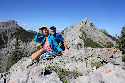
We got to the final hump before the final peak and decided we had gone far enough on this kind of trail. We admired the view for a while and went back down to the pass.
Behind us, are the south peak, the north peak sticking out to the right and the west peak to the left.
Coming up, I thought the return would be treacherous, but we chose our steps carefully without mishap.
 Red patches of Alpine Bearberry welcomed us back to the pass.


Sunday, 1 September 2019

81. Volcano Ridge

Distance: 10??km
Elevation gain: 320 m?

August 19, Monday we were camping at Blue Rock campground with Shixin, Kate and Stanley and decided to hike a trail marked on our old map.
 We started late morning on a wide equestrian trail and soon found churned up mud from the horses.
Although there were a few spots of this most of the trail was in excellent condition.
The fall flowers, especially asters, graced our stroll through the crown land and cow pies.
Eventually, we left our burbling brook
 and started climbing to the top of South Volcano Ridge.
The trees stopped and we could see our destination.
After lunch we climbed to the peak for a view -
and a photo.
We wanted to make a loop for the way back; our map showed this possibility, but our bushwhacking didn't cross another trail, just this spruce grouse.
So, still in good spirits, we agreed to go back the same way we had come. Going down was much easier and lots of fun. The trail had obviously been closed and/or rerouted over the years.

Tuesday, 6 August 2019

80. Grassi Lakes

Distance: 4.2 km loop
Elevation gain: 244 m

July 25, the fourth day of our hiking holiday, Herm and I met Rachel, Naylis, Skyler, and Allie in Canmore and we hiked Grassi Lakes loop together.
The falls which could be seen from the parking lot were our first destination.
It was a real hiking trail, not an abandoned road and after the falls we had some rugged climbing to do.
At the first lake we took a group picture.
At various spots on the trail there were rocks to climb and caves? to explore.
The second lake was even prettier than the first.
Then we started a steep climb up broken rock steps to find the petroglyphs which were supposed to be above us.
Allie, Naylis and I decided to continue to the top even though the wind threatened to blow us away.
At the top we looked over the edge to see the reservoir
and back over the way we had come to see the lakes, trail, canal and Canmore in the distance.
We went down again quickly as the wind was unpleasant.
A beautiful hike almost in the middle of town.
We took the easy road back to complete the loop.
Rachel and the kids had decided to count all the different wild flowers they could spot, a game we gladly participated in.  We noted about 40 kinds. One of the most common and most special was the wood lily.
According to Allie, this was one of the best hikes she has done.

Sunday, 4 August 2019

79. Asulkan Valley

Distance: 15 km return
Elevation gain: 925 m

Tuesday, the second day of our hiking holiday, Marg, Doreen, Herm and I left our hostel at Field fairly early to travel to Glacier National Park to hike the Asulkan Valley trail. The weather was perfect and we anticipated a wonderful day.
The trail was beautiful, very walkable with different flowers all along. The first ones were red monkey flowers.
Higher up were bouquets of gentians.
All along the trail were spiky flowers ready to bloom. We could not find them in any of our flower books and suspect they don't grow in Alberta.
The trail started through the woods but soon opened up with views of mountains, the creek and waterfalls all along beside us.
Eventually we saw a steep moraine ahead of us with a trail on top. This brought us to the end of the trail.
We continued up a little further to an outhouse and hut where we rested and sheltered from the wind and brief rain storm.
Thankfully the dark weather didn't last long.
Soon we took off our coats again, looked at the trail down the valley below us and set out for a great hike back down.

Wednesday, 31 July 2019

78. Sunshine Meadows

Distance: about 12 km
Elevation; about 500 m

On Monday, July 22, Margaret, Doreen, Herm and I started a hiking holiday. Our first stop was Sunshine Meadows in Banff, an easier start to our hiking list. We had done this for our 12 1/2 wedding anniversary and looked forward to doing it again.

The gondola took us up from the parking lot to the Village. From there we followed a circuit around various lakes and through meadows amid many wild flowers and past many people on a gorgeous sunny day.

Our first stop was Rock Isle.
We enjoyed our lunch with this view.
Next we hoped to continue to Grizzly Lake but the trail was closed because 2 grizzlies had been seen there shortly before. A park attendant was manning the gate to be sure we didn't enter.
On our retreat, we met another attendant who said the bears had moved on and fortunately we could continue. We enjoyed the hike to Grizzly Lake and noted the great burn at Simpson Pass a few years previous.
From there we continued to Laryx Lake and watched a silent loon.
Continuing on, we climbed to a constructed viewpoint which allowed a full overview and let the viewer put all the lakes in order.

 We continued on through slightly marshier meadow with fewer people and different flowers to Monarch viewpoint. From here we could see where we had hiked from Healy Pass a few years previous.(in the background)
We continued back to the Village down a long ski slope in the good direction in time to take the chair lift for a final view of the area.