Friday, 15 July 2016

53. Rae Lake

Distance: 17.2 km return
Elevation gain: 366m

We had tried to hike to Rae Lake last fall but the path was under snow so we gave up and continued on to Tombstone Lakes which was easier to find. However, the trail looked so beautiful that I wanted to try again and we chose this day because we would meet Rachel and Esther and families in Peter Lougheed Park after the hike.
So despite the cloudy day and promise of rain, we set out at 8:30 on Tuesday, July 12. The first part was a hike up to Elbow Lake, very familiar to us by now.
This was a good place for our first snack stop; observing the lake and the massive Mount Rae on the other side. We would hike around over the shoulder and to the back to see Rae Lake.
A short walk along the edge of the lake brought us to the outlet or the source of the Elbow River.
The first few kilometres of the pass trail were wide, fairly level and easy walking; beautifully surrounded by mountains on every side.
Soon Piper Creek trails left the Elbow River trail amid unique, small rolling hills. I had hoped and expected from last fall's hike that these would be covered in flowers but they weren't; still very interesting.
Across from the route to Piper's Canyon was a cairn marking our route to Rae Lake and my second snack stop. I was starting to eat whenever I got hungry.
The trail to Rae Lake started through trees but soon opened to a spacious, green, friendly-feeling draw.
In this meadow and all around Rae Lake we kept seeing cute and aptly named elephant head flowers.
The clouds and drizzle changed to rain and our boots got drenched walking through wet bushes. We decided to look into waterproofing them before our hike to Assiniboine. Looking back, we enjoyed a small rainbow.
From the top of the grassy section, we could see Sheep Lakes in the distance - nothing remarkable - but there.
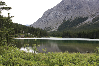
Then on over the shoulder of Mount Rae to a full view of Rae Lake, our destination. It was a beautiful lake but would have looked more dramatic in the sunshine.
We took a very brief break for lunch and pictures due to the rain.
 Rae Creek comes out the end of Rae Lake and flows into the Elbow River. Our route followed the creek in a loop back to the Elbow Pass trail.
The narrow, overgrowness of the trail through the woods was not pleasant and very wet.
We finally got through the woods and back to the friendly grassy draw and a final view of the north side of Mount Rae as a summary of our wet hike. Wet but not cold and full of energy now that we were on our return to a warm, dry car, we made it back in record time.
Sunday, 3 July 2016

52. Wind Ridge

Distance: 15.4km return
Elevation gain: 762 m

June 30 we biked and hiked to the Ice caves with Naylis and Skyler to celebrate Skyler's birthday. It was a workout, especially biking to the caves but we were still ready to do another  hike on July 2 to help us get in shape for an upcoming Assiniboine adventure and because we had heard of this beautiful hike which was not too far away. The trailhead was by Deadman's Flats with Pigeon Mountain and Centennial Ridge, both of which we had done and would see again from Wind Ridge.

So July 2, at 9:10 we started up to Wind Ridge after taking this picture of the distant ridge from the parking lot.
First we walked along a stream damaged from the flood and repaired with various quality bridges.
Then through the forest (Herm only found one ripe strawberry) and finally out to the open meadows with grass, steep slopes, the ridge before us and beautiful flowers all around us.
Fleabane and gallardia dotted the hillside, along with white yarrow, roses,pussytoes, stonecrop, scorpion weed etc. Higher up were a variety of saxifrage in the rocks.
Perhaps it was the time of year, but numerous butterflies livened our trek through the open areas, blues, fritillaries, white admirals, white and yellow sulphurs, swallowtails, and others we don't know because they wouldn't sit still long enough. The yellow sulphurs made the most contrast with the green grass but the orange and spotted fritillaries were the most numerous.
As we climbed we paid attention to Wind Pass beside us and noted the small mountain peak peeping through.
We had been warned repeatedly of the crux we needed to climb to get up on the ridge and were a little leery but if others could do it, we would try.
 As we ate our apples restoring our energy for the climb, some hikers came by from the right and told us there was a much easier access around the corner. We checked it out and sure enough it was nothing we hadn't done before, steep with lots of grip spots. We were thankful especially for not having to go down the cliff face.
Once we were up on top of the ridge, the view of Exshaw and the Bow River were expansive. Even Banff Resort is visible on the right.
The mountain views from the ridge were fantastic. The ridge was covered with grass and very friendly feeling. One fellow hiker at the peak took our picture in front of the Three Sisters.
We looked over at Wind Pass from the top of the ridge and could see a lot more now.
After a warm hour eating, sunbathing and swatting the pesky flies we went down. The forecast clouds were nowhere in sight.
It was hard to believe we hadn't noticed this blue-eyed grass right along the trail on our way up.